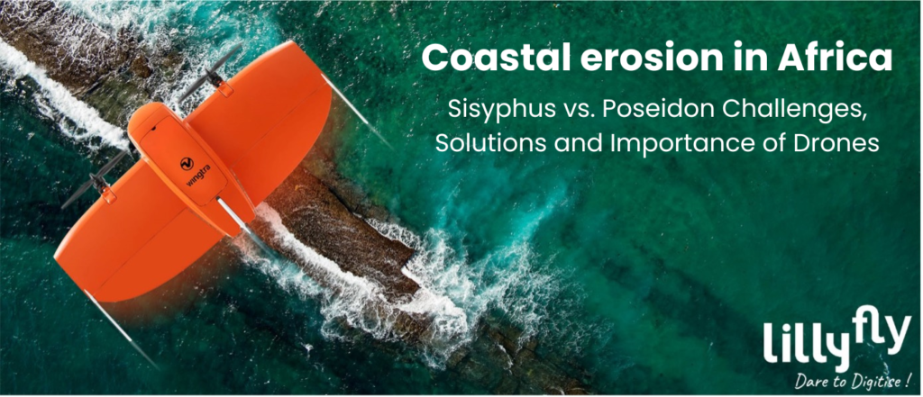
Challenges, Solutions, and the Significance of Drones
Coastal erosion in Africa is a growing problem that threatens not only the coastal environment, but also local populations and the regional economy.
In this article, we will examine the current state of coastal erosion in Africa, its impacts on coastal populations and the economy, ongoing actions and solutions, with a particular focus on requirements for projects as WACA, and finally, we will discuss the crucial role of drones and geomatics in managing this issue.
An already very alarming situation
Coastal erosion in Africa is a worrying phenomenon, exacerbated by a range of environmental, anthropogenic and climatic factors. Here are some concrete figures that illustrate the scale of the problem:
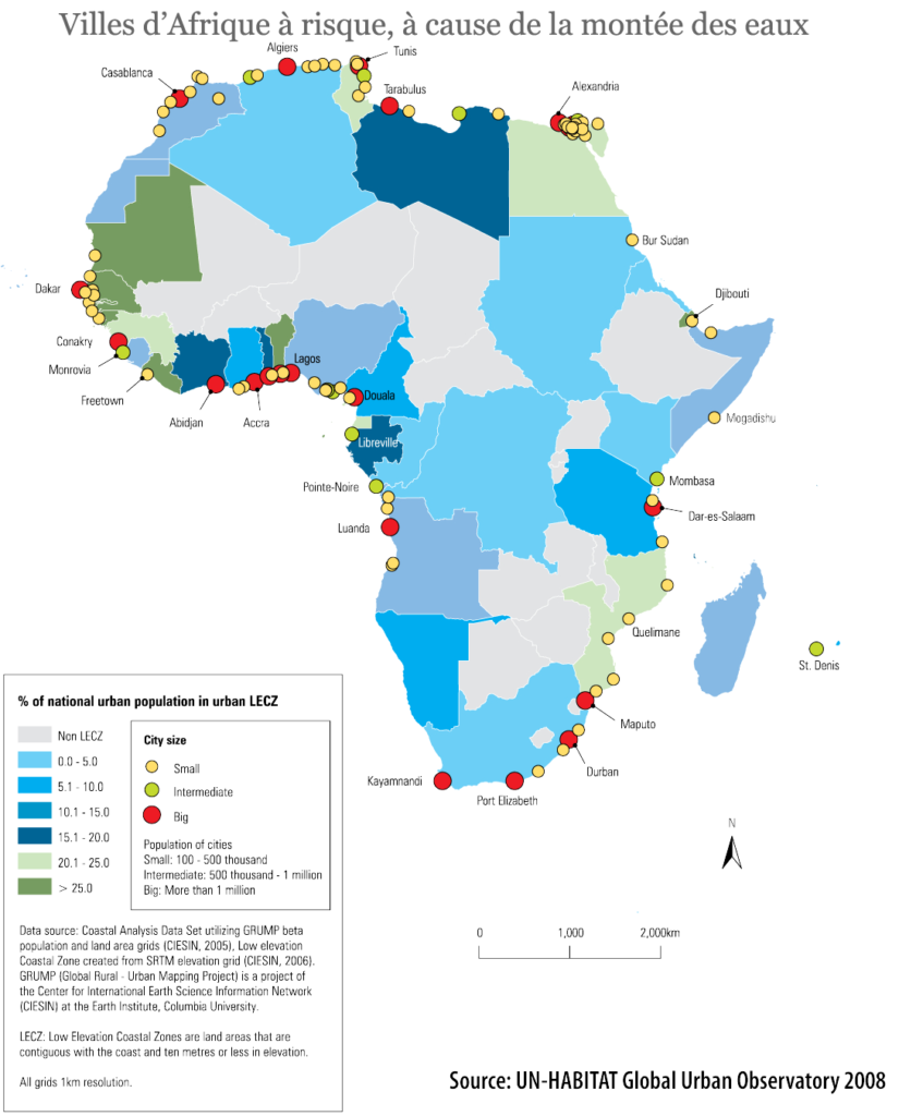
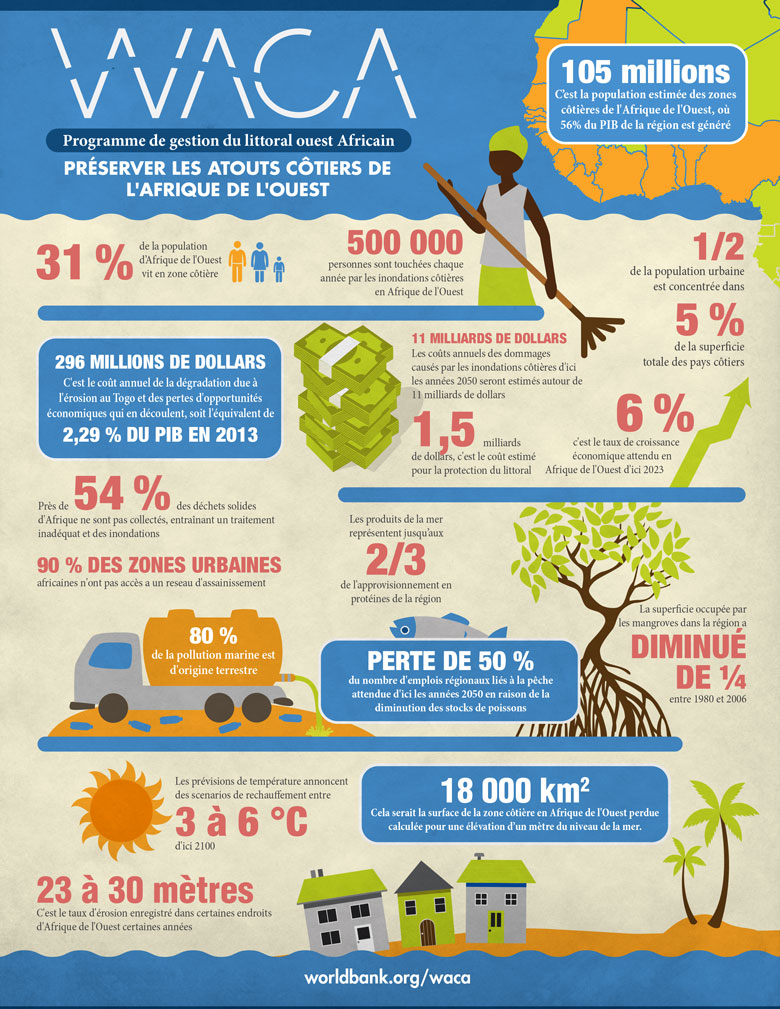
According to the Intergovernmental Panel on Climate Change (IPCC), sea levels have been rising at an average rate of about 3.3 millimetres per year since the 1990s. In West Africa, where there are large deltas, this rise is particularly worrying along low-lying and flat coasts, where even small increases can lead to devastating consequences, movements of populations deprived of work and places to live, and the irreparable destruction of natural and cultural heritage. It is estimated that the coastal population of West Africa is about 105 million people (it should be noted that these figures may vary depending on the sources and criteria used to define coastal zones). Population density along the coasts also varies greatly from country to country, with urban areas such as Lagos in Nigeria or Dakar in Senegal concentrating a large portion of this population.
Storms and extreme weather events are becoming more frequent due to climate change. For example, the number of tropical cyclones affecting the African coasts has increased in recent decades. These storms cause storm surges, coastal flooding, and increased beach erosion.
Katanga » fishermen’s quarter eaten away by rising waters – Lomé – Togo – 2022 – Lillyfly
Overfishing along Africa’s coasts affects marine ecosystems by disrupting food chains and reducing biodiversity. Decreasing populations of herbivorous fish, for example, lead to excessive growth of algae and seagrass beds, weakening the stability of the seabed and increasing vulnerability to erosion.
Unplanned Coastal Development: Rapid population growth and unregulated development along Africa’s coasts are contributing to the degradation of natural habitats and the loss of agricultural land. Coastal areas are often urbanized and industrialized without considering the risks of erosion and marine submersion, thus exacerbating existing problems.
The vegetable gardens of the Togolese coast formerly 300 m from the beach – Baguida – Togo – 2022 – Lillyfly
Repeated, unsuccessful attempts at diking and rock groynes – Baguida – Togo – 2022 – Lillyfly
A former 500m² grassy garden became a beach, then a threatening foreshore in 5 years – Baguida – Togo – 2022 – Lillyfly
The coastal road stops here now – Aného – Togo – 2023 – Lillyfly
Studies show that some specific regions are more vulnerable than others. For example, the coastline of West Africa loses about 1 to 2 meters of beach on average per year, while iconic sites, such as the historic city of Saint-Louis in Senegal, have lost up to 20 meters of coastline in just a few decades, or even a single tide.
Some less symbolic sites sometimes lose up to 50 m annually, as is the case on the urbanized coasts of Togo, and see houses, infrastructures and the last natural barriers sink.
Coastal erosion in Africa is a complex and multifactorial problem that requires a holistic approach and solutions adapted to local realities. The figures cited illustrate the urgency of taking measures to mitigate the effects of this phenomenon and protect coastal populations and fragile coastal ecosystems.
Africa’s coastal populations suffer serious consequences from coastal erosion. The loss of farmland and housing is forcing communities to displace, creating social and economic problems. In addition, local economies, often based on fishing and coastal tourism, are severely affected. The disappearance of beaches and coral reefs diminishes the attractiveness of tourism, while the depletion of fish stocks threatens the food security and livelihoods of fishing communities.
Act
In response to this crisis, actions are being taken at various levels to mitigate the effects of coastal erosion in Africa. The West Africa Coastal Areas Management Program (WACA) is a regional initiative that aims to strengthen the resilience of coastal communities in West Africa. This project implements coastal protection measures, coastal ecosystem restoration, and climate change adaptation programs. Governments, institutional donors and NGOs have been working for decades to fight against this scourge, which is getting out of hand and often goes beyond unsuitable or poorly sized projects in the face of this acceleration and too often poorly completed. The chain is complex mixing politics, economic lobbying, human and cultural constraints, science and big money…
Upstream of all these actions, it is essential to be able to follow, monitor and visualize the progress of the flows on the terroirs in order to be able to measure, quantify, plan, size and finance the right actions in the right place, at the right time and with the appropriate means.
The management (we cannot/no longer speak of control) of coastal erosion is complex and is based on a multiplicity of factors and possible responses, but also on scales of investments and actions. We are first and foremost dealing with a global and global issue, the actions have a macro and interregional scale and must certainly be concerted with an approach like that of the WACA project which coordinates the actions and supervises them. Space agencies such as NASA and ESA (European Space Agency) collect satellite data on the evolution of African coasts. This data is used to monitor changes in coastlines, estimate land loss, and assess environmental impacts. While they are valuable for a synoptic vision, they remain expensive, complex to exploit in tropical environments because of the swimmers’ coverage, limited in precision and require expertise and coordination of collection which makes it difficult to react and above all to be accessible to local operations.
Source Image : Banque Mondiale
It is essentially and above all locally that studies and actions for an effective fight are carried out, and they require approaches and qualified data that are much less macroscopic, recurrent and capable of understanding the many factors involved; Natural in all their complexities and interweaving, human, economic… and therefore require agile imaging solutions available on demand to serve the diversity of expertise needed.
Geomatics 3.0 versus Coastal Erosion
Geomatics plays a critical role in managing coastal erosion in Africa by providing accurate data that can be easily used by specialists and facilitating informed decision-making.
Satellite data has been a valuable source for decades, covering most of the needs for macroscopic and observational bands. However, they have limitations; the accuracy, which is certainly reduced to half a metre for the most efficient sensors, the various cloudiness that limit continuous availability in tropical areas and above all the combination of purchase costs and the means necessary for their interpretation. The plane can allow you to find an interesting in-between, but budgets, flight constraints and the weather also pose their limits.
Light or heavier drones provide a simple and effective response to local or even regional needs by involving purely national human and technical resources.
Here’s how these technologies help solve this problem:
Monitoring and Mapping
Aerial drones, equipped with high-resolution cameras and lidars, multispectral sensors, can fly over coastal areas at low altitudes, under tropical mists, thus collecting detailed data on the coastline. Their marine or submarine cousins complement certain studies to visualize what is happening under the surface thanks to sonars, radars and other sensors that make it possible to understand the invisible and to complete the sources necessary for studies.
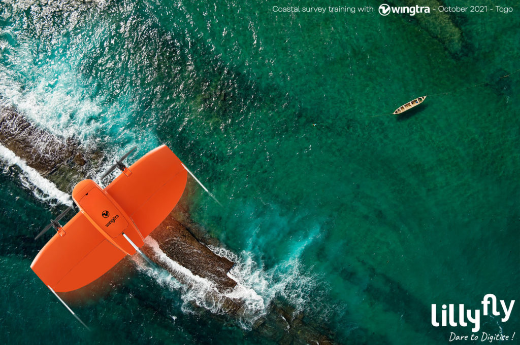
WINGTRA GEN II on the 57.3 km coastal strip in Togo over a width of 300 m covering foreshore, shoreline and land.
Implementation of the data acquisition procedure for the study of protective infrastructures – October 2022
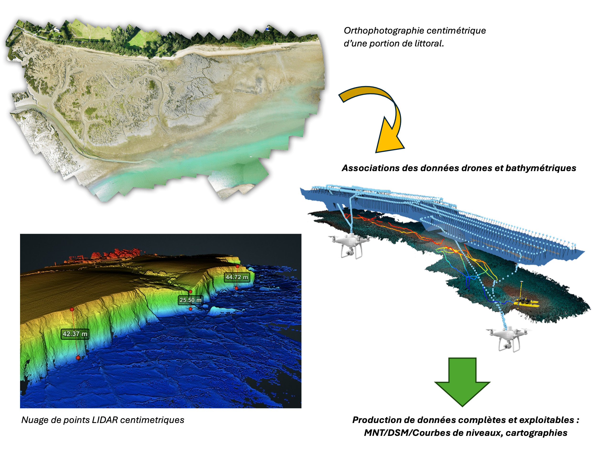
This data allows for accurate mapping of changes in the coastal landscape, such as beach erosion, loss of dunes and lagoon barriers, and reef degradation. Aerial imagery can be used to create digital terrain models (DTMs) and bathymetric maps, providing a complete view of underwater topography and geomorphological features. Multispectral, radar and thermal imagery, supplemented by missions and sensors at sea and on land, will provide key information on plant environments, detect subsurface flow wetlands and visualize currents.
Data Analysis and Modelling
The data collected is processed using geomatics software to analyse trends and predict future developments. Techniques such as photogrammetry and remote sensing can accurately measure changes in beach volume and estimate erosion rates. This data is then integrated into GIS (Geographic Information Systems) to feed experts in their thinking and strategies, simulate the effects of different interventions, such as the construction of breakwaters or the restoration of coastal ecosystems. Now easily made available in collaborative solutions, these models help decision-makers size, plan and evaluate the effectiveness of different adaptation strategies and optimize the allocation of resources.
Planning and Risk Management
Geospatial information produced by drones and geomatics is essential for land-use planning and coastal risk management. By identifying areas at risk of coastal erosion and predicting potential impacts on critical infrastructure, such as roads, ports, and industrial facilities, local authorities can take preventive and remedial measures to minimize human and economic losses. In addition, this data facilitates the implementation of coastal zoning policies and climate change adaptation plans, aimed at reducing the vulnerability of coastal communities.
In summary, drones and geomatics offer powerful tools to monitor, analyse and locally manage coastal erosion in Africa. By combining accurate data acquired at a lower cost, compared to conventional satellite and aerial images, and managed and processed by local skills with sophisticated numerical models, these technologies are cost-effective and available decision-making tools and contribute to the implementation of effective strategies to protect coastal populations and preserve coastal ecosystems.
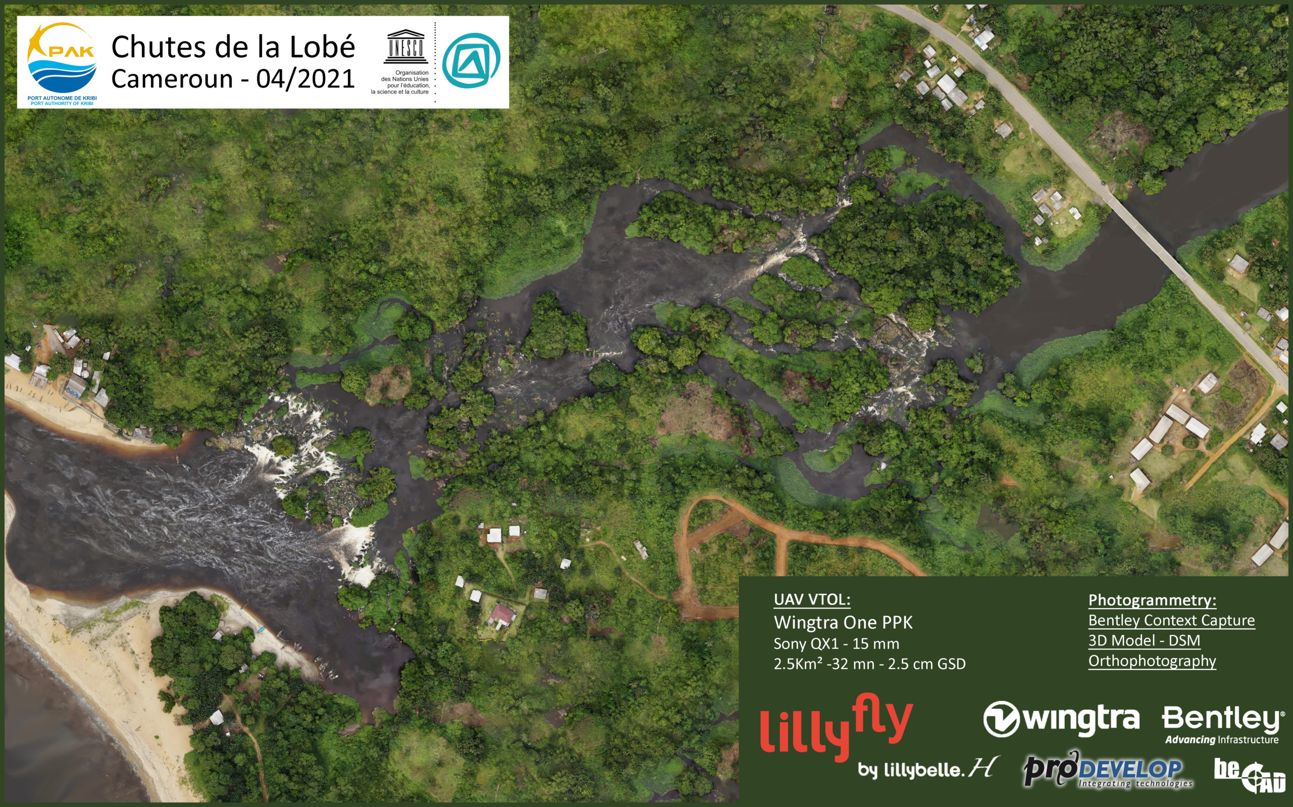
Mapping and monitoring of the maritime zone of the Lobé Falls in Cameroon
Unesco-listed tourist site – 2021 – LillyFly
It bears repeating, coastal erosion is a major challenge for the African continent that requires urgent and coordinated action. Solutions to unfortunately and only limit their impacts exist, but it is imperative to support them with effective tools and technologies such as drones and geomatics solutions. Investing in these solutions and training local teams is one of the crucial vectors to protect coastal populations, preserve the coastal environment, and ensure the economic viability of Africa’s coastal regions.
LillyFly teams with more than 5 years of operations in the sub-region from its base in Lomé in Togo, contributes modestly to equipping, training and supporting the actors of this Sisyphus-worthy fight.
Training of INROS LACKNER teams for the WACA project – Lomé – Togo – 2022 – LillyFly
By offering solutions such as the WINGTRA GEN II, a very versatile VTOL drone adapted to tropical conditions, adapted software suites and by training design office teams such as BOSCALIS, INROS-LECKNER, WACA’s international and regional experts and construction companies such as EIFFAGE, SOGEA SATOM in charge of implementing the solutions in place, Lillyfly is contributing to this important project and ensuring that it does not end up in the ocean to contribute to its elevation. Would you like to know more? Discuss our solutions?